
Bay Circuit Maps & Guides
The BCT has printable narrative guides and maps as PDFs. If you have difficulty opening any of these files, right click on the file, save to disk, and then open the saved file using Adobe Acrobat reader
Description of Section 1A, 07/2016
Map 1A, 02/2020
Newbury, Newburyport, Rowley
Section 1B
Hamilton & Essex is not yet available
Description of Section 2, 02/2020
Map 2, 02/2020
Rowley, Ipswich, Hamilton, Topsfield, Georgetown, Boxford
Description of Section 3, 09/2021
Map 3, 02/2020
Boxford, North Andover, Andover
Description of Section 4, 09/2021
Map 4, 02/2020
Andover, Tewksbury, Lowell
Description of Section 5A, 07/2017
Map 5A, 02/2020
Tewksbury, Billerica, Bedford
Description of Section 5B, 07/2016
Map 5B, 02/2020
Lowell, Chelmsford, Carlisle, Westford
Description of Section 6, 07/2017
Map 6, 02/2020
Carlisle, Bedford, Acton, Concord
Description of Section 7, 10/2021
Map 7, 02/2020
Concord, Lincoln, Wayland, Weston
Description of Section 8, 02/2020
Map 8, 02/2020
Sudbury, Framingham, Marlborough, Southborough, Ashland, Sherborn
Description of Section 9, 07/2021
Map 9, 02/2020
Sherborn, Medfield
Description of Section 10, 07/2017
Map 10, 02/2020
Medfield, Walpole, Sharon
Description of Section 11, 07/2017
Map 11, 02/2020
Sharon, Easton
Description of Section 12, 11/2020
Map 12, 02/2020
Easton, the Bridgewaters
Description of Section 13, 8/2020
Map 13, 02/2020
East Bridgewater, Pembroke, Hanson
Description of Section 14, 3/2022
Map 14, 02/2020
Pembroke, Duxbury, Kingston
How to Use the Bay Circuit Guide and Maps
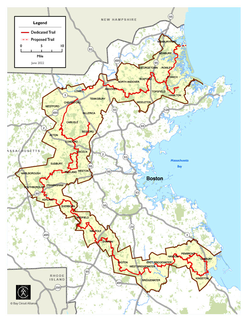
The Index Map shows the overall BCT and locates the detailed maps that apply to the area you may wish to walk, ski, or ride. On the Index Map, red indicates dedicated sections of the trail that we have completed, and, in most cases, blazed. Yellow indicates temporary trail used to bridge gaps or avoid problem areas, and may be blazed. Dashed green indicates proposed trail sections still being developed by local groups.
Each detailed map shows overlapping sections of the Bay Circuit Trail. Solid red trail shows dedicated trail, dashed red is temporary trail, and open red circles indicate proposed trail. The route of the BCT is described in corresponding text for each map, in the north-to-south direction. We encourage you to take copies of both the maps and descriptions with you, and these plus the trail markings should be adequate to follow the BCT. However, if you are interested in exploring the other trails shown, or in more detailed trail guides to the BCT, we strongly urge you to obtain local trail maps and guides. Those we know of are listed on the “For More Information” page that accompanies each map, along with information on where to obtain them. Trail users who are familiar with topographic maps may find the U.S.G.S. maps helpful. We’ve listed relevant area maps in each “For More Information” page.
Corrections, additions, and suggestions for improving the maps and associated text are very welcome. Please contact us about any suggested changes.